Give ArcGIS Grant, ESRI Indonesia Supports the Concept of IPB Agro-maritime 4.0
Agro-maritime 4.0 concept offer a development platform that integrates the management of land and sea territory inclusively which also supported by a strong social and economic capital and empowered by digital technology utilization to push the nation’s productivity. Digital technology creates agro-maritime management with high precision through artificial intelligence, drone application, remote sensing, big data, nanotechnology, and others.
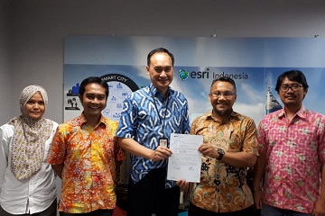
Along with the rise of remote sensing and geospatial information system technology utilization for research and education in Bogor Agricultural University (IPB), ESRI Indonesia gives a grant of ArcGIS platform ESRI software to IPB in ESRI Indonesia office, Menara 165 lt. 6, Jl. TB Simatupang, Jakarta, (23/11).
The handover of the server device (unlimited license) from ESRI Indonesia to IPB aims to support the management, analysis, and distribution of LAPAN A3 / IPB (LISAT) image data. This collaboration was catered by a Memorandum of Understanding between ESRI Indonesia and IPB signed on August 9, 2016.
Presence on that event was Dr. Achmad Istamar (CEO ESRI Indonesia), Dr. Yudi Setiawan (Faculty of Forestry IPB), and several staffs of ESRI and IPB. Dr. Yudi conveyed his high appreciation for ESRI Indonesia’s support to IPB through this server grant with high specification. He stated that the server would be used to strengthen the LISAT (LAPAN A3/IPB Satellite) data management and distribution facility, so in the future, the satellite data would be easier to access by the public.
“The ESRI Platform (ArcGIS) free license grant program, which is the part of the partnership between IPB and ESRI, has been very well in realization for the needs of students, lecturers, and IPB researchers. The ESRI license request procedure has been made so easy, which is filling forms in http://lisat.ipb.ac.id/esri, and later would be processed by ESRI. Besides that, several research results of IPB students have been published through ArcGIS online,” he added.
Dr. Achmad Istamar as the CEO of ESRI Indonesia delivered his greatest gratitude for the many research results in IPB that used ArcGIS application, and many results had been published. Regarding the satellite image data management, Dr. Istamar suggested the use of ArcGIS Image Server, so the public (user) could easily access the image data and analyze them accordingly without having to be burdened with a high internet bandwidth to download the data.
“This ArcGIS Image Server is making the management and distribution of data easier and more efficient. Image Server is one of the applications included in ESRI Enterprise Platform that is given to IPB,” he explained.
ESRI Indonesia hoped that the ESRI Platform software, namely ArcGIS desktop, ArcGIS Server, ArcGIS Online, ArcGIS Pro, Drone to map, and Image Server would be used by the academic community of IPB to actualize Argo-maritime 4.0. (CN)