IPB University Helps Mesuji Farmers Analyze Crop Conditions and Optimize Agricultural Production Using Drones
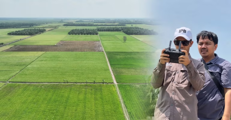
A team from IPB University collected data using drones to examine the condition of rice paddies in greater detail, enabling the mapping and analysis of agricultural patterns in the area.
The expanse of tidal rice fields in Tirtalaga Village, Mesuji Regency, served as the research site for a team from IPB University in collaboration with Muhammadiyah University (UM) Palembang and the Mesuji Regency Government.
The research, titled “Design of a Village Based Agricultural Geographic Information System Using Participatory Mapping and Artificial Intelligence for Economic Development in Mesuji Regency, Lampung” involved Dr Supriyanto and Dr Mohamad Solahudin from IPB University, Dr Jun Harbi from UM Palembang, and Dr Untung from the Mesuji Regency Agency for Regional Planning, Research, and Development (Bappelitbangda).
Dr Supriyanto stated, “The use of drones is one way to accurately and thoroughly analyze crop conditions in order to optimize future production.”
“With drones, we can get a more comprehensive view of land conditions from above. We can obtain data on rice fields, canals, and the surrounding conditions. We can later use this data to understand the characteristics of tidal lands in Mesuji,” he continued.
Dr Untung added, “This data is not only important for research purposes. If further developed, spatial land information can assist the government in planning agricultural development and land use in Mesuji.”
“The hope is that this data won’t remain merely research data. If it can be developed into information that the government and the community can use, it will certainly be more beneficial. Data driven agricultural planning will help us better identify Mesuji’s economic potential,” he expressed.
During the drone data collection, the team also met with Sikun, the Village Chair of Tirtalaga. This meeting was crucial because the conditions of tidal lands cannot be fully understood through data and maps alone.
Sikun is a transmigrant who has lived in Tirtalaga Village for a long time. He explained how the local community adapts their farming activities to water conditions that change throughout the seasons.
The rice fields in the area are surrounded by canals connected to the Mesuji River. During planting seasons (MT) 1 and MT 2, the water can still be used for farming. However, as MT 3 begins, the water becomes brackish, making it difficult for farmers to continue farming.
“During MT 1 and MT 2, the water can still be used for farming, but as MT 3 approaches, the water starts to become brackish. So we really have to monitor water conditions and adjust our farming activities accordingly,” said Sikun.
According to him, the community actually already has experience dealing with these conditions. However, support from technology and research is expected to help farmers better understand the land’s conditions.
“We hope this research can help the community. Farming here is indeed different because it depends on water conditions. If we can understand the land better, hopefully farming here can continue and become more sustainable,” he said.
For the research team, the community’s experiences, as shared by Sikun serve as a vital complement to the data collected via drone technology.
Technology provides an aerial perspective, while the community shares stories and firsthand experiences of what happens on the ground. Both are then combined to gain a more comprehensive understanding of the challenges facing tidal agriculture in Mesuji.
For Mesuji, tidal rice fields are more than just expanses of land. They embody the lives of the community, experiences of transmigration, sources of livelihood, and economic potential that must be managed sustainably. (*/Rz) (IAAS/LAN)