Chairman of IPB University’s Center for Environmental Science Development Emphasizes Spatial Mitigation Due to Land Cover Change in Sumatra
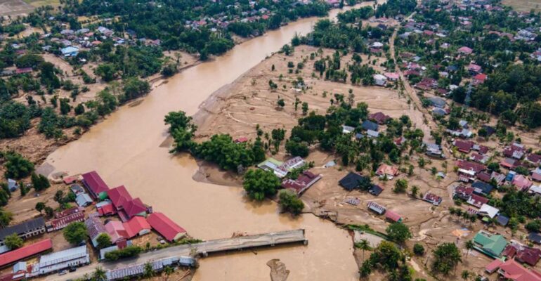
Chairman of IPB University’s Center for Environmental Science Development (PPLH), Dr Yudi Setiawan, emphasized that the hydrometeorological disasters that struck Aceh, West Sumatra, and North Sumatra serve as a serious warning of the increasing risk of disasters on the island of Sumatra.
In LRI Talk #3 with the theme “Together Protecting Sumatra: Collaboration in Mitigation, Law Enforcement, and Ecosystem Restoration to Deal with Hydrometeorological Disasters,” Dr Yudi emphasized the importance of understanding the dynamics of land cover change in relation to disaster risk.
“This disaster is a lesson for all of us that humans are a small part of the natural system. We need to be wise and science-based in responding to disasters,” said Dr Yudi.
He explained that in addition to extreme natural factors such as tropical cyclones, which crossed Sumatra for the first time, changes in land cover also exacerbated the impact of disasters. In a hydrological and erosion approach, land cover is a factor that can be controlled by humans, unlike rainfall or soil characteristics.
“In various hydrological models, land cover is always a key variable. Deforestation or changes in vegetation have been proven to increase surface runoff and the risk of flooding,” he explained.
Based on an analysis of data from the Ministry of Forestry for the period 2003-2024, a team of researchers from IPB University noted a significant trend of change from forest to non-forest in these three provinces. In Aceh, many forest areas have been converted into plantations and dryland agriculture. Meanwhile, in North Sumatra and West Sumatra, secondary and primary dryland forests have been converted into plantations, agricultural land, scrubland, and open land.
Dr Yudi also highlighted that land cover change is not always linear. “In one area, vegetation can disappear, become open, and then grow back. It is important to understand this dynamic pattern, especially when it is linked to extreme weather events,” he said.
To support mitigation efforts, IPB University, together with the National Research and Innovation Agency (BRIN), has developed a rapid detection system for vegetation cover changes based on satellite imagery that can monitor changes on an eight-day scale. This system has been utilized as part of early warnings for forest cover loss, including in the Sumatra region.
As a recommendation, Dr Yudi emphasized the need for upstream rehabilitation of watersheds and riparian areas, tightening forest clearing in disaster-prone zones, auditing and restructuring oil palm plantations, and strengthening integrated early warning systems.
“Going forward, spatial planning must be adaptive to climate change and disaster risk-based so that similar incidents do not continue to recur,” he concluded. (AS) (IAAS/RWA)