IPB Researcher: Bogor Must Strengthen Landslide Mitigation
The increase of land load in sloping areas and mountains will automatically increasing the potential for landslides. Indeed, at this time the Bogor area is in a normal state, but it is not impossible if the rainfall continues to increase, it will lead to greater potential risks.
This was conveyed by Dr. Heriansyah Putra as Head of the Natural Disaster Division, Center for Disaster Studies, Institute for Research and Community Service (LPPM), Bogor Agricultural Institute (IPB) when visiting the fracture of half of the road around Riung Gunung, Puncak Bogor (29/11). The Fast Response Team consisting of Dr. Heriansyah together with the Secretary of the Center for Disaster Studies LPPM IPB, Dr. Perdinan and Program Director, Dr. Syamsul Bahri visited to see firsthand the possible risks that could occur from the crack.
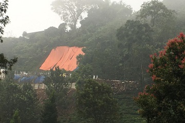
When the visit was carried out at one of the landslide location points and experienced a road fracture, the roadside has been repaired and strengthened. Seen some other landslide points have been covered with tarps. Roadside construction work continues to operate and economic activity looks normal.
"We see a higher land load on slopes, rainfall and reduced land capacity to absorb rainwater because of the limited number of plants being considered as a shift and crack like what happened in Riung Gunung," he said.
As a result of the site visit, the Fast Response Team delivered several important things in disaster risk mitigation. First, the need to monitor the condition of the area and land with potential cracks and landslides by monitoring soil movements. The second builds a slope reinforcement system, whether artificial biology or artificial technology. Third, reduce activities that can increase slope loads such as traffic density, buildings and other infrastructure.
"It is important to prepare a monitoring tool that can be evaluated at each vulnerable point. To see whether mitigation efforts are necessary or not done, the first step that must be taken is to map landslide-prone areas with functional monitoring tools. If along the slopes there is the potential for landslides, the tools can be installed along the area," he said.