IPB University’s PPLH Develops a Near-Real-Time Air Quality Monitoring System to Track the Impact of Forest and Land Fires
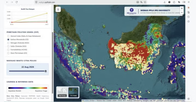
The recent forest and land fires (karhutla) have not only caused ecosystem damage and the loss of natural resources but also have the potential to pose serious problems for air quality and public health. The smoke and various pollutants produced can spread beyond the fire sites and affect air quality over a wider area.
In response to this situation, the Center for Environmental Research (PPLH) at IPB University has developed a near-real-time (NRT) satellite based air quality monitoring system specifically designed to track forest and land fires. The system is integrated into a WebGIS platform covering the entire territory of Indonesia, with the latest data updated and published daily.
The system can be accessed at https://webgis.pplhipb.com. It was developed to provide a spatial overview of forest and land fire incidents as well as the accompanying changes in atmospheric conditions. Users can not only identify the locations of hotspots but also monitor air quality conditions and their relationship to fire incidents on a day to day basis.
According to Tubagus Ahmad Mufawwaz, Chairman of the Environmental Instrumentation and Monitoring Laboratory at PPLH IPB University, the system integrates several satellite remote sensing data sources. This integration is designed to facilitate the spatial and temporal monitoring of fire indicators and changes in atmospheric conditions on a single platform.
“With this near-real-time system, the latest information can be updated and published daily via the WebGIS dashboard. Historical data is also retained so that we can track the progression of events over time. By integrating hotspot data and atmospheric conditions, we can analyze the spatial and temporal relationships between forest and land fires and changes in air quality,” explained Fawwaz.
Dr Yudi Setiawan, Chairman of the PPLH at IPB University, noted that the recurring forest and land fires highlight the need for a monitoring system that not only provides information on fire locations but is also capable of illustrating the environmental impacts they cause, particularly on air quality.
According to him, satellite technology offers the opportunity for broader and more consistent monitoring, especially given the vast size of Indonesia and the limited coverage of ground-based air quality monitoring stations.
“Since forest and land fires keep recurring, it’s not enough to just know today’s conditions. We also need to understand the patterns of these events: where fires recur, when their intensity increases, and how air quality changes in response to these events. Time-series data is crucial for building that understanding,” added Dr Yudi.
The PPLH at IPB University believes that the integration of fire and air quality data can serve as a scientific information source to support the government and various stakeholders in determining priorities for monitoring and managing karhutla.
This system is also expected to complement existing monitoring systems by providing an analytical perspective on the spatial and temporal relationships between forest and land fire events and changes in air quality conditions.
Moving forward, the system will continue to be developed through the integration of various satellite data sources, ground based air quality observation data, and other meteorological and environmental information. This integration is expected to strengthen the analysis of the relationships between fire sources, meteorological conditions, pollutant dispersion, and changes in air quality.
Further development is also aimed at creating an air quality early warning system related to karhutla, so that the information generated not only describes conditions that have already occurred but also supports faster anticipation and decision making.
“Thus, this technology can evolve into a decision-support system for mitigating the impact of forest and land fires on air quality in Indonesia,” concluded Dr Yudi. (*/Rz) (IAAS/EPK)